Portland on display: Five favorite Portland viewpoints for Photographers
Portland, the City of Roses, has always been a playground for photographers. Its eclectic mix of architectural styles, lush green spaces, and dramatic bridges, all set against the backdrop of the stunning Pacific Northwest, create a canvas begging to be captured.
And what better way to truly appreciate this city’s beauty than from its various viewpoints? These are spots that perfectly frame everything Portland has to offer, ensuring every snap you take will be a stunning memento of your visit.
Best Viewpoints to photograph Portland, OR
1. International Rose Test Garden
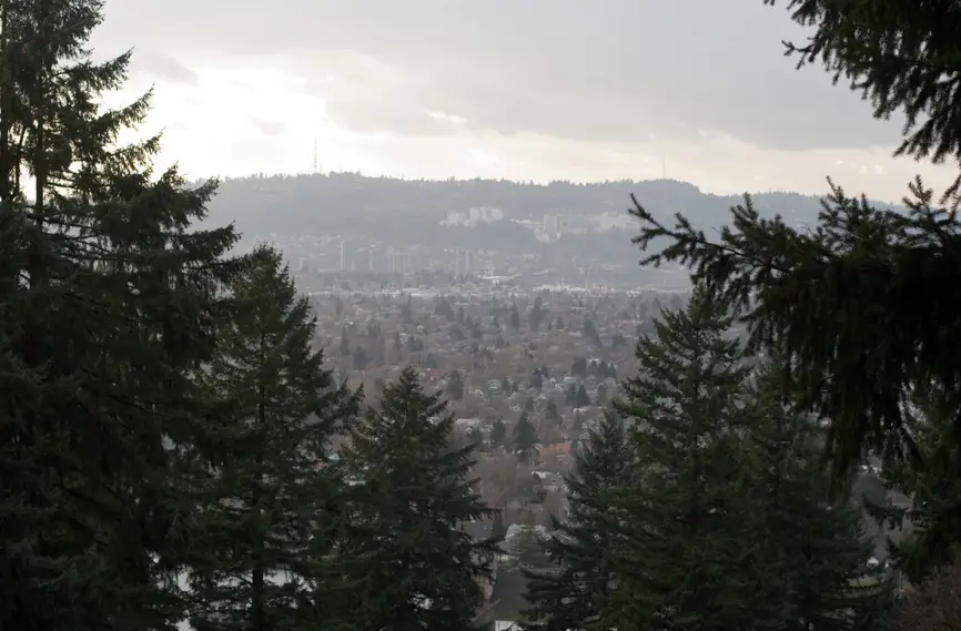
One of the first spots likely to come up when chatting about a Portland visit is the International Rose Test Garden. It sits atop the city in Washington Park, a collection of lawns with even, rectangular plots planted with the most spectacular array of roses in the state, if not on the West Coast altogether.
Portland’s nickname “the city of roses” is derived from the original test roses planted along the city’s first thoroughfares. The climate here is perfect for rose growing, and these flowers make the best possible frame for a view of Mt. Hood on a clear day. Park near the tennis courts at the entrance of the garden (near the signs for the Japanese Garden, also worth seeing) and head down a series of staircases onto the main rose garden lawns.
A brushed silver fountain sculpture marks the pathway to the opening in the evergreens, which makes for the best view. Late spring through mid-summer are the best times to see the flowers and the view, but honestly, the whole Washington Park area is marvelous any time of year. Just don’t expect a view if there’s any cloud cover or rain.
It’s worth noting that when you’re searching for the rose garden online this is also the name of Portland’s largest stadium and concert hall, where soccer and other sports are played. Be sure to specify Washington Park in your search to be sure you don’t mistakenly take your grandma to roller derby! Other rose gardens in the city worth a look-see are the geometrically-designed gardens in Ladd’s Addition, and the Peninsula Park gardens, with more than 9,000 rose varieties and other views.
In 2023, the Gardens hosted the Oregon Brewers Festival.
To get to the rose gardens, take SW Tichner off W Burnside, turn right on Kingston, and turn left at the second stop sign.
2. Marine Drive at the I-205
On the outskirts of the city, closer to the Columbia River and not the more central Willamette, there aren’t as many café-speckled neighborhood streets, but the area is the gateway into the Columbia River Gorge, one of the most spectacularly beautiful places in the United States, and thus its high points offer a great perspective of the sweeping mountain views.

Head north on Interstate-205 as if you were going to cross the river to Washington State. At the very last exit in Oregon, directly before the bridge, head onto Marine Drive and park along the river, looking east toward the Gorge. On a sunny day, Mt. Hood will be in the center of your view, with the river current briskly washing by. This may seem like an unlikely place for a view, but it is worth the trek, or the stop on your way out of town, to see the surrounding landscape that made this area so enchanting to its first Western explorers.
Look at a Streetwise Map, or on Google Maps, for this offramp and overpass where the Mt. Hood view is unexpectedly amazing.
3. Sauvie Island
For an entirely different view, a wilder one complete with bird-watching opportunities, head north on Route 30 to Sauvie Island’s Wapato State Park. Take NW St. Helens Road over the bridge to Sauvie Island Road, and veer left, passing Kruger’s Farm Market then Ferry Road. You’ll find yourself in an often-missed park, cherished by bird lovers. The jungle-like foliage is dense and delicate, so raised wooden pathways allow you to circumnavigate the central pool of marshy waters, called Virginia Lake. Here, drastic changes in water level throughout the year allow for various plants and wildlife to vividly display their cycles.
The marshlands are fed by the confluence of the Columbia River, the Willamette River, and several large creeks, making it a must-stop migration spot for the winged. More than 250 species of birds can be found year-round on the island, most of them in this park. Look for viewing points along the trail through which to see the yellow bills of the Sora Rail and, if you are lucky, an endangered and tiny bird that visits Sauvie in the late spring, the Willow Flycatcher. It is a lovely walk any time of year, even when it is grey and you become saturated by your environment. While you are heading back into town keep your eyes peeled for Osprey, but don’t stop long on the road to view them, the residents ask.
Find Wapato State Park, Sauvie Island on Google Maps at the south end of the island, just up the western tip of the island at Virginia Lake. Bikeable, but roadways do experience flooding during periods of high precipitation!
4. Mt. Tabor
Located in Portland’s Southeast, the assets of Mt. Tabor vary depending on who you ask, and when. Dogs have their sights and smells on the large wooded dog park area, joggers head for the paved and unpaved paths around the reservoir, and hikers take the steep route.
Annual festivals such as the Soap Box Derby and the Doodle Dog Day, or summertime Wednesday Night Bike Races are the only times when Mt. Tabor is what you’d call crowded, but then the spectacle is even more worth the bus ride.
To take in the view any time of year wind upwards on a trail – there are several trails that are all connected, and unmarked – you’ll get to an elevation where breaks in the evergreen foliage make way for epic city views.
Because the mountain is a solitary bump in an otherwise rather flat corner of the city, you can catch glimpses of both the city’s heart and the snow-veined mountain peaks in the other direction. In the early morning, this hundred-year-old park is especially magical, and also on a clear day at sundown. If you are interested in bird-watching, keep your eyes peeled for winged friends like red crossbill finches, hooded warblers, and golden-crowned kinglets.
5. Portland Aerial Tram
The Rosy City centers around two rivers – at the very middle of the Willamette River shores at Tom McCall Park – with the hills rising up on either side. But the left side (looking north) and the right don’t elevate at the same rate, which leaves especially the southern area of Portland’s west shore cut up 700 feet towards the sky in a matter of blocks. Perched atop this hill are OHSU, Oregon Health and Science University, and hospital, plus west hill neighborhoods like Marquam Hill.
To bridge the steep gap an aerial tram was built – one of only two to operate in US cities today – that would make it easier for commuters, visitors, students, employees, and anyone who wants, to climb to the upper rim of Portland. The tram car itself is wrapped with sturdy plexiglass panels, and the views are breathtaking. Take the trip with those heading to work and class and head into the air. It’s $8 round trip if you aren’t a visitor of the hospital, but if you have a monthly transit pass, it is considered a part of the city’s public transit network.
Find the lower tram entrance at SW Bond and SW Whitaker Sts, past the parking garage.
Prices & some details updated in late 2023.
Before you go…
Get Travel Insurance!
We use and recommend WorldNomads. Learn about Travel Insurance.
Find Great Tours
We start looking for food tours, historic tours, and mini-adventures right here.
Book flights – and save!
We’re using WayAway for cheap flights with cashback! Save 10% off WayAway Plus with coupon TP-450933
We use Travel Payouts, Amazon Affiliates and other programs, and may receive a commission if you purchase through links on this site.

Portland seems like a beautiful place, especially the rose garden 😉
Thanks for a detailed and thorough article.
We’re getting more and more excited about visiting some day. If we ever get around to a North American road trip, Portland will definitely be a stop.