Three ways to improve your American road trip
If you’re heading out on the road this summer, don’t forget to use the power of the Internet to make your traveling easier. Here are three quick ways to do that:
One: Find unique roadside stops
RoadsideAmerica.com is a user-contributed collection of the quirky road-side stops that dot America. Want to see the world’s largest ball of twine? Here it is in Cawker City, Kansas. Perhaps a homemade X-wing is more your style. Or who could pass up such temptations as The Thing or the Mystery Hole?
It’s easy to find something that interests you, just use the Roadside America map to take a state-by-state look at what’s near your driving route. Particularly handy is the ability to sort based on user reviews or categories such as ‘worth a detour’ or ‘worth a stop’.
Two: Find the best route
ZipperMaps is a site that plans the shortest driving route between multiple locations using Google maps.
Unlike most driving-directions sites, which require you to put in the order of the places you want to visit, ZipperMaps needs only a starting and ending position — it will figure out the order you should visit your stops to minimize driving.
To show you an example, here’s a road trip itinerary starting in North Carolina and ending in California that goes through 17 cities.
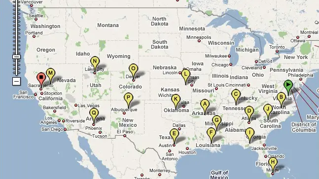
Trying to find the shortest route between all those cities is near-impossible to do by hand, but ZipperMaps will find it for you. Here is the solution for the above example:

For a real-life example of the time this site can save, my wife and I are taking a road trip across eighteen states and British Columbia this summer. The best route we could figure out on our own was 131 hours of driving. But ZipperMaps found a 99-hour solution. We’re going to save 32 hours of time. That translates into more time seeing sights, rather than driving to them.
Three: Don’t get tickets
One danger of a United States road trip is your license plate. Once you drive across your first border, that out-of-state plate reads like a big ‘ticket me’ sign to the local cops.
This is where Trapster comes in. It’s an application that you download for your iPhone or Android phone that alerts you when you’re nearing a speed trap. (Here’s a demo video of how it works.)
I recommend always driving below the speed limit anyway for three reasons:
- You don’t really get there much faster.
- It is safer if you get in an accident.
- It’s not worth the constant stress of looking out for cops.
However, it still helps to know where the speed traps are — you don’t want to give the police any excuse to pull you over. I normally drive at the speed limit, but when I know there’s a trap ahead, I go under the limit.


My only advice would be to remember how vast America is and plan your time accordingly. When my British friend started to plan his American Roadtrip he wanted to see Yellowstone, Chicago, the Grand Canyon, New Orleans- just about everywhere. I had to explain to him that my family spent 3 months doing what he was planning to do in 3 weeks and that unless he was planning on giving up sleeping it was pretty impossible.
Go on a motorcycle!
Where will you be staying? I recommend camping. My husband and I camped/drove across the US and Canada and into Alaska this summer and camped for 2 months straight. We used KOAs when we needed internet (KOA.com) and a shower and rough camped when we could get away with it (plus we had 2 dogs with us, so hotels were mostly out of the question). KOA runs about $25/$35 a night, but it includes shower facilities, internet, usually a pool and mini-golf course and they’re almost always located right off the highway and have late night check in. Not for everyone, but being online is important, then it’s a good deal.
In the rural areas it is easy to just find a little dirt road to camp off.
I would never have guessed KOA stood for Kampground of America in a million years.
Great suggestions, everyone.
@Wellington Grey:
I think a motorcycle gives you a connection with the road and a unique travel experience. You notice and see more since your senses are heightened and there’s no opportunity to get distracted as easily as you can in a car, bus, etc.
@Stephanie: I’ve lived in London for six years and it took me a long time to figure out how to quickly make an Englishman understand the size of the US. I used to say that the States is three times the size of the European Union but that didn’t really have the impact I was looking for. Finally, I figured out that English people think driving to Scotland is quite a journey. Now I compared the drive from New York to Florida to the one from London to Istanbul and they get the idea immediately.
@Anil: I’ve never understood the appeal of motorcycle travel: it combines the worst attributes of bicycles and cars with no extra advantage.
Wow, never heard of Zippermaps. That will be perfect when I plan my rollercoaster tour of The States! 🙂 Thank you!
Thanks for the introduction to Zipper Maps, and I totally agree with Stephanie, and am glad to have @WellingtonGray’s suggestion of London to Istanbul.
Good post.
Great post! I never knew about Zipper Maps until now! That can definitely come in handy road tripping across a country as vast as the US. Thanks for the info, Wellington!
It does look like a great tool, huh? I’d be really interested so see something similar for European rail journeys or something like that.
Once you have considered where you are going, what you would like to see, and how you are going to get there in the time allocated, consider booking your accommodation through various Youth Hostels and self contained accommodation. We can provide online 24/7 bookings for any trip within the USA and worldwide.